Smart tech helps communities stay ahead of disasters: WATEC
Smart flood warning towers, automated flash flood and landslide alert stations are among the latest technological solutions helping communities access information quickly and respond in time.
Smart flood towers deliver on-site warnings
Recent years have seen multiple cases of rapid-onset flooding, highlighting a persistent gap between macro-level forecasts and on-the-ground warnings. While authorities may track overall weather and hydrological developments, residents in low-lying or riverside areas often only recognize the danger when water has already reached their homes.
Speaking at the workshop “New Technologies in Disaster Forecasting and Early Warning” on March 18, co-organized by Vietnam Agriculture and Nature News, the Vietnam Meteorological and Hydrological Administration (VNMHA), and the Community-Based Disaster Prevention Fund, Le Viet Xe, MSc., representing the Water Resources Engineering Consultancy and Development JSC (WATEC), said that Vietnam’s terrain and rapid urbanization make flooding more sudden and complex, while real-time monitoring data at the community level remains limited.

According to Xe, flood warnings based on river alert levels often fail to accurately reflect conditions in specific localities. This reduces the effectiveness of early warning systems, despite their critical role in giving people time to evacuate, protect assets, and prepare response measures.
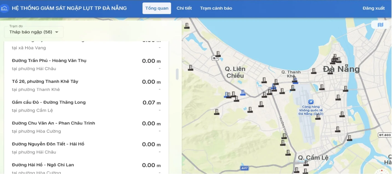
To address this gap, the automated flood monitoring system VFASS (smart flood warning tower) has been developed to measure inundation levels in real time at critical locations. The system uses radar sensors to measure water depth and, together with data collection and communication modules, continuously transmits information to a central management platform.
When water levels exceed safety thresholds, the system automatically sends alerts to residents and authorities via multiple channels, including SMS, mobile applications, loudspeakers, and disaster management platforms. As a result, risk information is delivered directly to affected communities rather than remaining at a general forecast level.
Notably, the system is designed to operate reliably under disaster conditions. Powered by solar energy with lithium battery backup, it can continue functioning during widespread power outages. Data is transmitted via telecommunications networks, temporarily stored during disruptions, and automatically resent once connectivity is restored.
All monitoring data is processed on cloud-based platforms, enabling real-time system tracking, reporting, and data sharing. By integrating multiple functions into a single device, the smart flood tower model simplifies deployment in both urban and residential areas.
Field data drives flash flood and landslide warnings
Beyond urban flooding, prolonged heavy rainfall also triggers flash floods and landslides in mountainous regions, hazards that occur rapidly, within limited areas, but with high levels of risk. Effective warning systems for these events must rely on localized data rather than broad forecasts.
Automated warning stations are designed to integrate data from rainfall gauges, water-level sensors, and flood warning towers. When rainfall or water levels exceed critical thresholds, the system can issue immediate alerts to communities through sirens or public broadcasting systems.
The operational process is fully automated, following a chain of sensing, data processing, transmission, visualization, and multi-channel alerting. Warning thresholds are calibrated based on observational data and scientific research to reflect local conditions, recognizing that the same rainfall intensity may pose different risks depending on terrain and infrastructure.
The system is built on a network of automated rainfall stations, which WATEC has developed and refined over the past decade. These stations can transmit data over dual telecommunications networks and operate on grid power, solar energy, or backup batteries that can sustain operations for 45 to 60 days during outages.
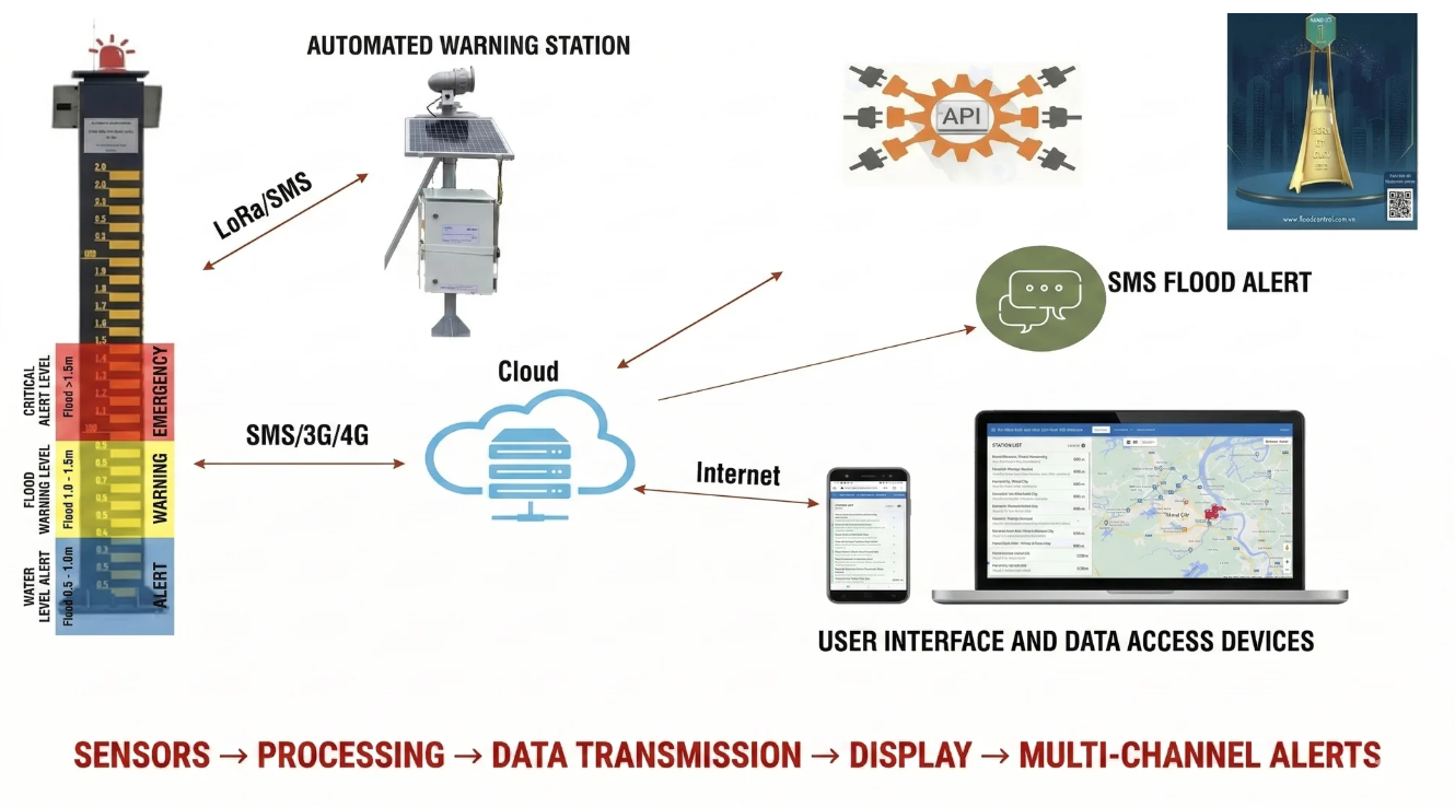
Even when communication links are disrupted, data is stored locally and transmitted once connections are restored, ensuring continuity of monitoring. The system’s ability to operate independently of a single network provider further enhances reliability during emergencies.
Beyond immediate warning functions, data collected from monitoring stations also provides long-term value for planning and disaster risk management. Information on rainfall, water levels, and inundation is integrated to develop flood maps and predictive models.
Experts emphasize that modernizing observation and early warning systems is essential to reducing disaster losses, particularly as climate change intensifies extreme events. Accurate and timely data enables a shift from reactive response to proactive prevention, helping safeguard communities.
According to WATEC, domestically developed technological solutions offer advantages in cost and adaptability to local conditions. To date, the system has been deployed in multiple localities, including around 140 smart flood-warning towers and automated flood-monitoring stations, 74 automated warning stations, and approximately 2,800 rainfall-monitoring stations nationwide.
Trung Hieu - Hoai Tho