Forest boundary map launched to help three commodity sectors comply with EUDR
Version 1.0 of the 2020 Forest Boundary Map provides consistent nationwide spatial data to help the timber, rubber and coffee sectors meet the requirements of the EU Deforestation Regulation (EUDR).
On October 20, the Viet Nam Department of Forestry and Forest Protection (VNFOREST) held a technical meeting to launch Version 1.0 of the 2020 Forest Boundary Map (VFM2020.v1) and provide guidance on its use. The map is designed to help the timber, rubber and coffee sectors demonstrate that their products are not linked to deforestation or forest degradation, as required under the European Union Deforestation Regulation (EUDR).
Speaking at the meeting, Mr. Nguyen Van Dien, VNFOREST Deputy Director and a member of the EUDR joint working group, stressed that the regulation sets increasingly stringent requirements for legality, traceability and evidence that commodities do not originate from land deforested after December 31, 2020.

“For Viet Nam, meeting these requirements presents challenges for exporters, but it also provides an impetus to modernize forest management, digitize forest resource data and enhance the international reputation of the country’s agricultural and forestry products,” Mr. Dien said.
In practice, businesses are using different map sources to cross-check information for EUDR compliance. Differences between datasets can make it difficult to establish forest conditions at the reference date, particularly in areas where perennial industrial crops are grown.
The timber, rubber and coffee sectors can use the map as a tool to collect, compare and verify information when fulfilling their due diligence obligations under the EUDR.
More than 4.2 million forest plots assessed using multiple data sources
Presenting the process behind the map, Dr. Pham Van Duan of the Institute of Forest Ecology and Environment said VFM2020.v1 was developed by building on local forest management data, applying scientific analysis methods and cross-checking the results against international reference datasets.
Local authorities provided forest cover data for 2020 as the initial dataset. Experts then analyzed satellite imagery from multiple periods, compared different data sources and identified areas where discrepancies required further verification.
The mapping process also involved local forest protection authorities, which helped review, adjust and supplement the information. This approach aimed to ensure the final dataset was scientifically grounded while reflecting actual forest management conditions in Viet Nam.
According to Duan, one important reference source was data from the European Commission’s Joint Research Center (JRC), which was used to compare information and identify areas where different forest mapping systems showed discrepancies.
Combining multiple data sources helps reduce reliance on any single mapping method and makes it easier to identify potentially inaccurate areas that require further review.
The assessment covered more than 4.28 million forest plots nationwide. To support the review process, the expert team provided local authorities with several data layers, including the original forest map, a consolidated map with attribute information, a layer showing forest plots with changes, and satellite imagery for cross-checking.
Local forest protection authorities were trained to use the data, examine individual cases, compare the findings with management records and propose adjustments supported by evidence. Each locality received its own data access link, while feedback and revisions were recorded to support updates in subsequent versions.
According to the expert team, local authorities’ involvement not only helps improve the map’s reliability but also provides a basis for standardizing how forest data are managed, shared and updated nationwide.
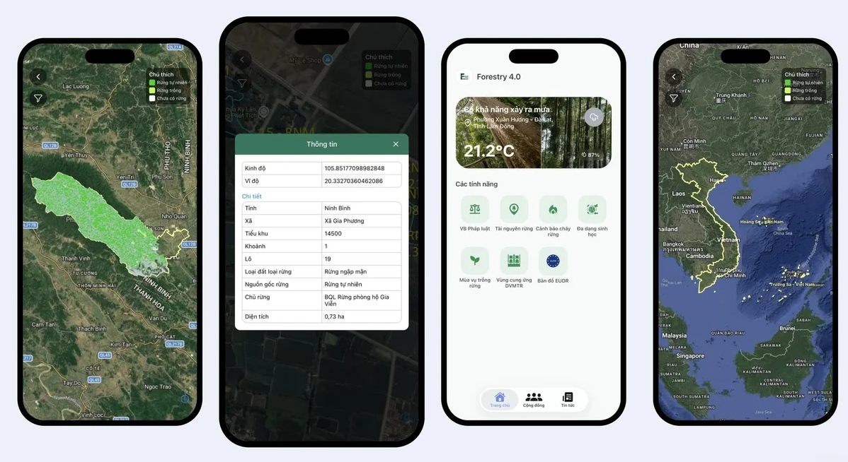
A tool to help review forest maps
Alongside the map’s launch, the Viet Nam Department of Forestry and Forest Protection provided guidance for agencies, organizations and businesses on accessing the data through its online platform at eudr.vnforest.gov.vn.
The platform allows users to look up forest boundaries as recorded in 2020 and compare them with the geographic locations of production areas. This helps them identify potential overlaps between raw material sourcing areas and the forest areas shown on the map.
For timber, rubber, and coffee exporters, access to a consistent spatial dataset can support checks on raw material sourcing areas, help identify where additional information is needed, and guide field verification where necessary.
The map also provides a basis for closer cooperation between businesses, producers and local authorities to standardize information on growing areas and raw material sourcing zones, helping reduce traceability risks.
However, the authorities stressed that VFM2020.v1 is a reference dataset for assessing potential risks, not the sole basis for determining whether a product complies with the EUDR.
Determining compliance still requires a comprehensive assessment of traceability records, geolocation data, evidence of land-use conditions, the legality of production activities and other relevant due diligence requirements.
Starting with this first version, the 2020 Forest Boundary Map is expected to gradually evolve into a spatial database that supports forest management and helps agricultural and forestry supply chains meet international market requirements. In doing so, it could strengthen the competitiveness of Viet Nam’s products and promote more sustainable production.
Quynh Chi